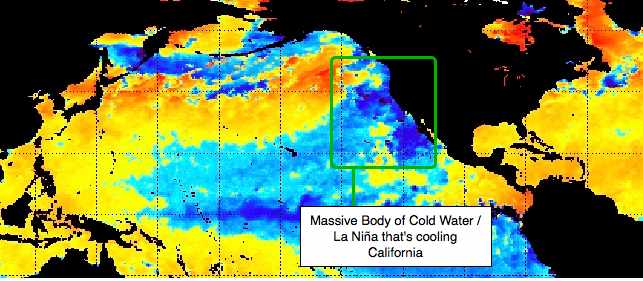
While we have warmed up somewhat in the past week, anyone who lives in San Diego can tell you how cold and gloomy the summer has been. In typical San Diego summer, there is a period in May and June where the cold water off the coast fuels a persistent fog layer that spreads miles inland, keeping the area cooler that the latitude would proscribe and giving rise to what the natives call “June Gloom”. In most years, this pattern breaks by the 3rd week in June, and gives way to hot, sunny days moderated in the afternoon by a strong sea breeze.
Not so this year. The gloom was entrenched until mid-August. One likely explanation is a massively cold area of water in the eastern Pacific. This is frequently referred to as La Niña, the cold counterpart to El Niño’s warmer than normal water.
At the moment, science is not able to connect our diminished solar radiation to the cooling of the eastern pacific. But if the lowered solar output is a driver for this, North America could be in for some unwanted weather patterns.
For starters, it could be very cold indeed over California and Nevada this winter. With that huge pocket of cold water driving our air temperatures, we could see much lower daily lows than we are used to. If this acts like the last La Niña, we could see a lack of rain this winter in the southwest, putting further strain on our sources in the Sierra and the Colorado River.?